Can the public archive see what the research radars saw?
KCBX · PAYETTE MOUNTAINS, IDAHO · JANUARY 2017The best-documented cloud seeding events in history happened over Idaho's Payette Mountains in January 2017. The SNOWIE experiment's two mountaintop X-band research radars watched aircraft silver-iodide legs turn into trains of parallel reflectivity lines — the zig-zag signatures — and tracked them for hours (Friedrich et al. 2020, PNAS). But nobody's forensic workflow gets research radars. What the public gets, forever and for free, is the WSR-88D archive: here, KCBX, in the valley at Boise, 60–100 km from the lines, at S band, with its beam a kilometer or more above the terrain.
So this case asks the question every future "we found a seeding line on radar" claim depends on: knowing exactly when and where documented seeding lines existed, can we find them in the public archive? We rendered every KCBX volume through two of the three quantified SNOWIE cases — 19 January (six seeding tracks, 1619 UTC onward, lines over the gauges 1705–1806 UTC) and 31 January (two legs, lines crossing the domain 2117–2151 UTC in 30 m/s flow) — on a weak-echo color scale resolving −10 to +30 dBZ MEASURED.
Finding one: the false positive comes first
19 JANUARY · EXHIBIT AOn 19 January, the sector east of Packer John — exactly where the paper says two seeding lines drifted over the Silver Creek and Banner gauges — shows narrow, elongated echo streaks that an eager eye would call seeding lines. They are not. The control test settles it: the same streaks, in the same places, are present 77 minutes before the seeding aircraft released anything. They are terrain-locked echoes off the Boise Mountains ridgelines, and they sit there all day.
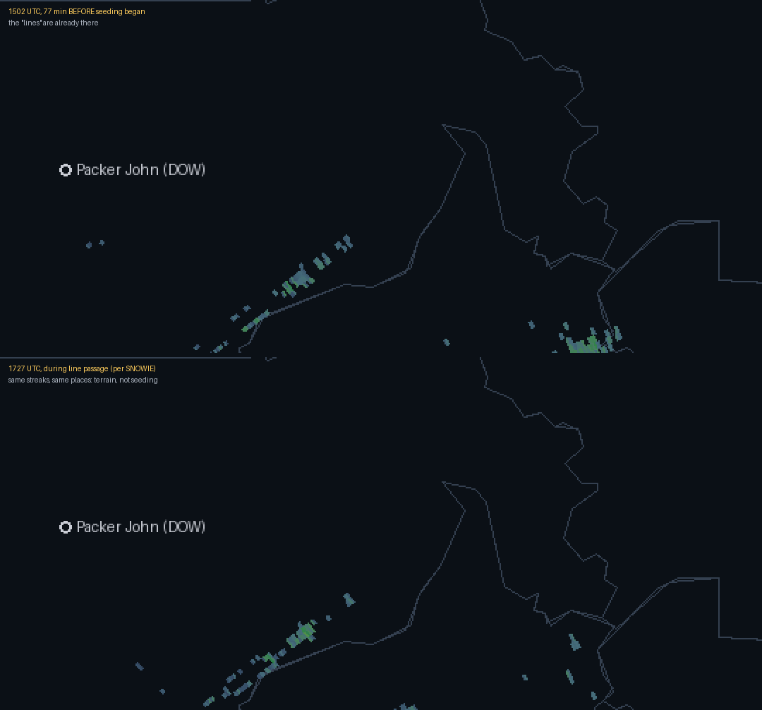
The documented lines themselves — 1 to 15 dBZe on the X-band research radars — do not appear at all in the KCBX volumes. This is precisely what the detectability theory predicts (Zaremba et al. 2023: a seeding signal needs roughly 5 dB over the natural background, and range, beam height and beam filling all work against a distant valley radar). The false-positive streaks and the true-negative lines are, together, the whole lesson.
Finding two: one candidate, honestly labeled
31 JANUARY · EXHIBIT B31 January was the strong case — the research radars saw the lines above 20 dBZe. And in the public archive, at 2108 UTC, a narrow, ~15 km echo appears a few kilometers south-southeast of Packer John: oriented crosswind (the direction a seeding leg is flown), absent in the 2057 volume, and gone — translated downwind — by 2118. Time, place, orientation and motion are all consistent with the paper's northern seeding line en route to Silver Creek (which it crossed 2120–2142 UTC).
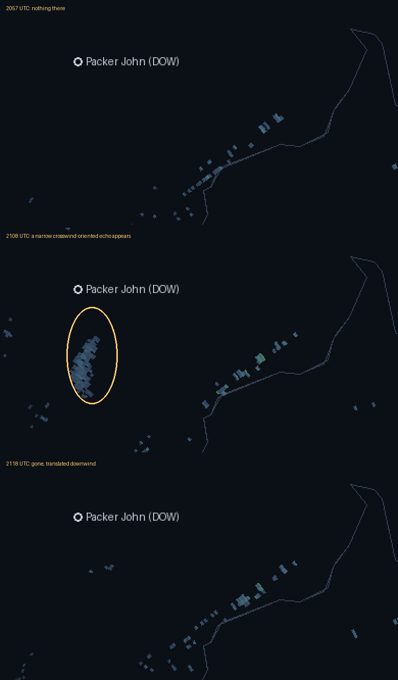
Label discipline: the echo is MEASURED; the attribution is consistent with, not proof of, the documented seeding line. A 2–6 dBZ feature caught by a single 10-minute-cadence clear-air scan, without dual-polarization corroboration, does not clear this site's own bar for a confirmed detection — and if we won't hold our best candidate to that bar, we cannot hold anyone else's claim to it.
What this case calibrates
1. The persistence test is mandatory. Any claimed seeding line must be absent before seeding and must advect with the wind. The most convincing "lines" in this hunt were rocks. 2. Non-detection is the expected outcome. The best-documented seeding lines in history are, at public-radar range, invisible (19 Jan) or marginal (31 Jan). Anyone claiming routine seeding detection in NEXRAD over mountain programs is claiming to beat physics. 3. The archive still matters. One transient crosswind echo, timed to the minute against a filed operation, is exactly the corroborating layer — flights, environment, radar — this site's forensic method stacks. No single layer convicts; five layers agreeing do.
Method and data: KCBX Level II from the unidata-nexrad-level2 open archive; lowest-tilt reflectivity rendered at −10..+30 dBZ (ingest/nexrad_case.py); 65 rendered volumes published under /data/cases/kcbx-20170119/ and /data/cases/kcbx-20170131/. Seeding times and line positions from Friedrich et al. 2020 (PNAS 117:5190); detectability framework from Zaremba et al. 2023 (JAMC 63:27). DOW site markers are approximate landmarks, not analysis inputs.